

Bioregional Mapping Workshop — What Happened and What We Learned
Bioregional Mapping Workshop — What Happened and What We Learned
Hello,
Here is a crisp field note from our recent bioregional mapping workshop. The goal was simple and ambitious at once — clarify why we are here, surface what we want to learn, test practical mapping approaches, and name what it will take to activate bioregional work with care and rigor.
Why we gathered
We opened with four prompts to set shared intent:
Why am I here
What I want to learn
How I plan to use this
What I can offer

Participants named a few clear motives. Learn practical methods and best practices, connect mapping with existing ecosystem and actor maps, and test approaches that can be measured, validated, and improved. Many are working on bioregional projects already and want coordination and synthesis, not just more data.
What people want to learn
How to start with what already exists. Identify local and global datasets, public repositories, and practical tools.
How to bridge tools and people. Use mapping to support navigation and coordination among relevant actors, not just create artifacts.
How to build knowledge ecosystems and commons. Weave stories, governance, culture, and resource flows into one living picture.
How to keep it practical. Translate mapping into next actions for local teams and learning centers.

Voices from the circle
Paper and place still matter. Several participants value tactile maps for inclusion and shared understanding, especially for those new to digital tools.
The map is not the territory. We need layers that include inner journeys, values, and lived practice, not only geospatial attributes.
Respect the crow nest view. People with deep field experience help us see the cliffs and constraints. Their signals deserve weight.
Plan for a moving climate. Design for near future conditions, not past baselines. Long range certainty is limited.

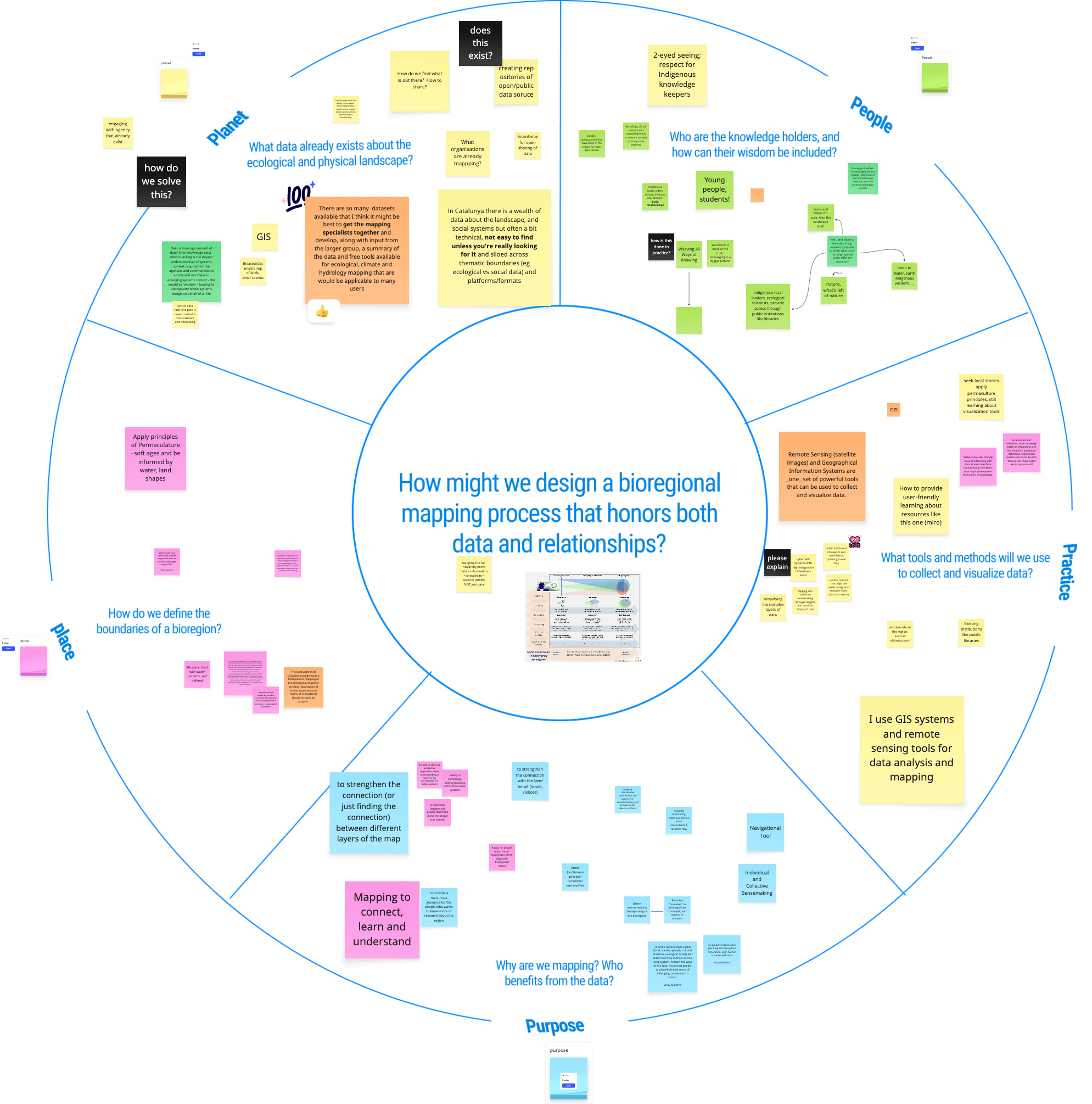
A working principle set
Start with existing knowledge. There is more data than time. Curate first, then add.
Synthesize and simplify. Turn complex datasets into decision support that local actors can actually use.
Include many ways of knowing. Indigenous and community wisdom, western science, and practitioner insight all belong.
Map the light and the shadow. Show assets and opportunities, and also the constraints that block action such as planning laws, ownership, and governance.
Share with care. Sensitive ecological and cultural information must be protected. Build commons with thoughtful access.
Tools we explored
We walked through a relational mapping stack that supports both sensemaking and communication.
Represents people, projects, places, and their relationships.
Can embed background layers and create guided presentations for city councils, funders, and community briefings.
Works well with Google Sheets for live data updates.
Collects survey data with built in relationship tagging.
Pipes structured updates into Kumu for network maps that grow over time.
Tally and Google Forms
Easy front doors for community input.
Connect to Google Sheets which then feeds Kumu.
Hybrid build options
For advanced needs, pair form builders with dedicated storage such as Supabase, Cursor and use AI assisted coding tools to create custom bridges. Useful when a project needs unique workflows.
Examples on the board
We reviewed living references including a permaculture map for Ontario, rivers of the North Sea bioregion, a decolonial atlas, and an agri food systems presentation built in Kumu. These show how multi scale views and lightweight presentations can move a conversation from spreadsheet to story.
What’s next
Living lab proposal
Create a living lab that takes one bioregion as a case study and builds an experimental Kumu map for a single bioregional learning center. A small team of 5 to 7 people would collaborate over two months to explore what is possible with these tools and to showcase the work we do together. The outcome would be a living map that makes the invisible visible and helps the learning center communicate clearly with community members and stakeholders in order to secure more funding for their regenerative portfolio.
A closing note
The Miro board we used during the workshop is now open as a living space for collaboration. You can revisit the prompts, see everyone’s post-its, and keep adding new ideas, resources, and reflections. Think of it as an evolving field notebook — a place to weave insights, examples, and tools from your own bioregion into our shared map of learning.
Please add your thoughts, links, or visual notes — even small contributions help keep the map alive and continuously enrich the shared understanding of what bioregional mapping can become.